This ‘river’ of warm water that moves through the Atlantic Ocean is called, in various places, the South Atlantic Current, the North Brazil Current, the Caribbean Current, the Yucatan Current, the Loop Current, the Florida Current, the Gulf Stream, the North Atlantic Current (or North Atlantic Drift) and the Norway Current.
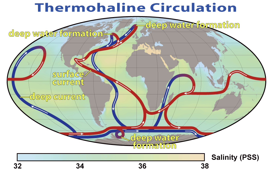
The thermohaline circulation is sometimes called the ocean conveyor belt, the great ocean conveyor, or the global conveyor belt.
It is a university level physics experiment to use a tub of cool water and inject a colored stream of warm water into it. You can see the boundary layers of the warm water stream. If you add oil to the tub it breaks down the boundary layers of the warm water stream and effectively destroys the current vorticity . This is what is happening in the Gulf of Mexico and in the Atlantic Ocean.
The entire ‘river of warm water’ that flows from the Caribbean to the edges of Western Europe is dying due to the Corexit that the Obama Administration allowed BP to use to hide the scale of the BP Deepwater Horizon Oil Disaster. The approximately two million gallons of Corexit, plus several million gallons of other dispersants, have caused the over two hundred million gallons of crude oil, that has gushed for months from the BP wellhead and nearby sites, to mostly sink to the bottom of the ocean. This has helped to effectively hide much of the oil, with the hopes that BP can seriously reduce the mandated federal fines from the oil disaster. However, there is no current way to effectively ‘clean up’ the bottom of the Gulf of Mexico, which is about half covered in crude oil. Additionally, the oil has flowed up the East Coast of America and into the North Atlantic Ocean, and there is no way to effectively clean up this ’sea bottom oil’. It is likely, based on numerous reports, that the oil is still flowing in massive amounts from multiple places on the seabed floor. This effectively means, that even if we had the technology in place to somehow clean up the free flowing thick crude oil deep in the ocean, it would likely not be enough to reverse the damage to the Thermohaline Circulation System in the Atlantic Ocean.
Dr. Deagle: The evidence has come in from ROV video and other experts such as Matt Simmons, BK Lim, and Lindsay Williams and my own anonymous whistleblowers from inside the closed circle of Cameron Ironworks, Tranocean Marine , Oceaneering International. My source provided very solid info re the ROV analysis by Oceaneering engineers that the BOP Blow Out Preventer was ‘modified’ and never had hydraulics to close the BOP. BP knew that the field had dangerous high levels of methane, hydrogen sulphide, and pressures exceeded any valve technology as the current state of the art. The seeps continue along a fractured fault line from the Macondo well site where evidence presented by BK Lim that the only well of three that reached the abiotic batholith ocean of oil and gas was never capped or stopped and has continued to leak along the ocean floor and inject oil and gas and tar into the rock strata.
Dr Gianluigi Zangari PhD from the Frascati Institute is a Theoretical Physicist, who has worked for years with a collaborative network of scientists monitoring the Gulf of Mexico Loop Current and its contribution to the Thermohaline Current System that makes the Gulf Stream that becomes the North Atlantic Drift Current and subcurrents. After receiving a contact from a naval scientist via a regular guest on the NutriMedical Report national radio show, on Genesis Network, John Moore sent Dr. Deagle the info on Dr Zangari’s work. Dr. Deagle contacted him by SKYPE and and within minutes was conversing by SKYPE to Italy with Dr Zangari re his serious analysis with data from six satellites of the May to June 12th 2010 dissolution of the Loop Current. Over the next few weeks to July 28th, with numerous interviews on The NutriMedical Report and LiveStream.com/TheNutriMedicalReportShowupdates, final proof was provided that the Gulf Stream had been stopped cold at the 47th longitudinal parallel with a 10 degree Celsius ocean temperature drop, and loss of velocity and energy, so that the Gulf Stream was only able to be measured by satellite to less than one-third the way across the Atlantic ocean. As Dr Zangari stated, this is not the butterfly effect but the ‘elephant effect’, and with the amount of oil released, the natural system linked as the pacemaker to world climate for millions of years, this was now gone, replaced by an artificial system with a Gulf of Mexico by late July seven degrees Celsius above normals, and totally disconnected Loop Current from the Florida current that becomes the Gulf Stream. In his reported on June 12th 2010 in a journal article, the CCAR Colorado data agreed with the NOAA and US Naval Satellites data. This live satellite data map later altered on the CCAR servers, and he emailed that this was “to falsify” and he could not explain this fact logically. He returned to NOAA and US Naval data on the same and later dates and stated by early August that the CCAR data was no longer reliable and his conclusions was not changed in quality or quantity of the serious consequences. His conclusion that ‘glaciation’ at an unknown pace was inevitable from this disaster.
Almost a month ago, we broke the story that the Loop Current in the Gulf of Mexico had effectively died. We quoted Dr. Gianluizi Zangari, who first discovered the damage to the Thermohaline Circulation System:
“As displayed by both by the sea surface maps and the sea surface height maps, the Loop Current broke down for the first time around May 18th and generated a clock wise eddy, which is still active. As of today the situation has deteriorated up to the point in which the eddy has detached itself completely from the main stream therefore destroying completely the Loop Current. ..”
“It is reasonable to foresee the threat that the breaking of [such] a crucial warm stream as the Loop Current may generate a chain reaction of unpredictable critical phenomena and instabilities due to strong non-linearities which may have serious consequences on the dynamics of the Gulf Stream thermoregulation activity of the Global Climate.”
- Dr. Gianluigi Zangari
The massive amount of crude oil, ever expanding in volume and covering such an enormous area, has seriously affected the entire thermoregulation system of the planet, by breaking up the boundary layers of the warm water flow. The Loop Current in the Gulf of Mexico ceased to exist a month ago, the latest satellite data clearly shows that the North Atlantic Current is now GONE and the Gulf Stream begins to break apart approximately 250 miles from the Outer Banks of North Carolina. The Thermohaline Circulatory System, where the warm water current flows through a much cooler, much larger, ocean, effects the upper atmosphere above the current as much as seven miles high. The lack of this normal effect in the eastern North Atlantic has disrupted the normal flow of the atmospheric Jet Stream this summer, causing unheard of high temperatures in Moscow (104F) and drought, and flooding in Central Europe, with high temperatures in much of Asia and massive flooding in China, Pakistan, and elsewhere in Asia.
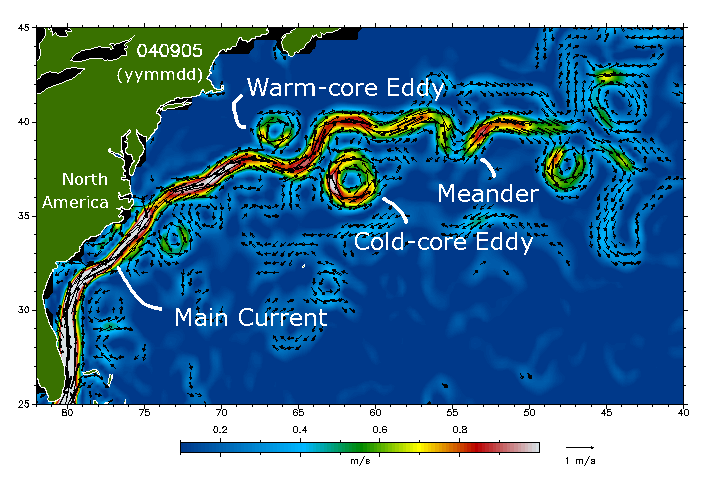
A Normal Gulf Stream taken from 5 September2004.
Figure 2. Gulf Stream velocities two weeks ago: Sunday 15 August 2010
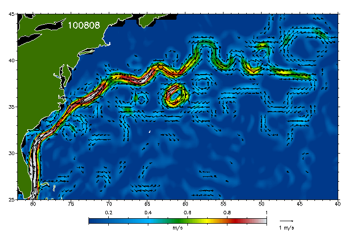
Figure 3. Gulf Stream velocities three weeks ago: Sunday 8 August 2010
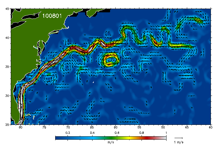
Figure 4. Gulf Stream velocities four weeks ago: Sunday 1 August 2010
Older data charts:
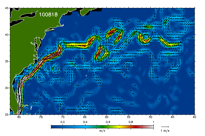
Figure 1. Gulf Stream velocities one week ago: Wednesday 18 August 2010
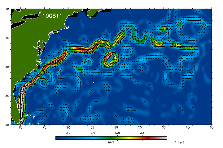
Figure 2. Gulf Stream velocities two weeks ago: Wednesday 11 August 2010
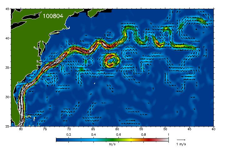
Figure 3. Gulf Stream velocities three weeks ago: Wednesday 4 August 2010
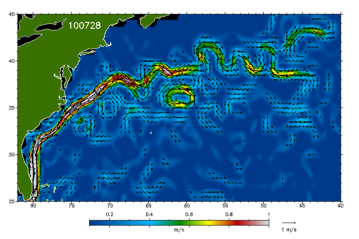
Figure 4. Gulf Stream velocities four weeks ago: Wednesday 28 July 2010
The most current data continues to show a dying of the entire Thermohaline Circulation System in the Atlantic Ocean. This is indicative of the fact that the dispersants have caused the oil to remain in place below the surface, and according to most reports remain in almost full amounts (up to 80%) long after the BP Oil Disaster began. Since there is no current way to remove this massive amount of free flowing oil below the sea at depths up to one mile deep, it is apt to continue to effect any natural recovery of the Thermohaline Circulation System.
So what does this mean? Violent mixing of the seasons, crop failures, and increased drought and floods in diverse places is now daily news since the April 20th 2010 BP Oil Volcano. They have killed the pacemaker of world climate in the worlds of Dr Zangari PhD. Dr Mike Coffman PhD geologist resource climatologist, and Dr Tim Ball PhD climatologist have confirmed that if this data is correct, that an ice age and massive climate shift with famine is now imminent. We are now seeing Russia stop all delivery of wheat crops on prior contracts, and most sources of staple food crops moving worldwide in a crisis of famine. The Gulf Stream and related currents are effectively DEAD. This should enrage the public and bring forth scientists to challenge and support the data and analysis, for the consequences to the civilization of mankind and ecological collapse have global consequence producing famine, death and massive population migration away from zones of advancing ice age and regions unfit for human habitation. Let us get the facts and call the corporate and government to task on these issues now or face worldwide catechisms of biblical proportions. We shall continue to report with new scientific experts on this most important disaster.
The ‘process’ of entering a new Ice Age could begin coming upon us in full force (rather like in the movie “The Day After Tomorrow”) at any time, or it could take three to five year to fully play out with early glaciation beginning in North America and Europe and Asia this winter (both models have existed in the beginnings of different Ice Ages in Earth’s past).
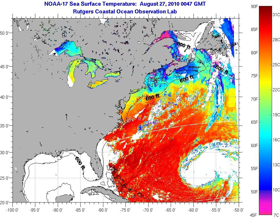
Current sea surface temperature satellite data show pre-Ice Age cooling continuing - image ~
A new Ice Age, could kill 2/3 of the human race in the first year in a rapid onset; a slower onset would likely kill close to this number but simply take a handful of years.! Thank you BP; thank you President Obama, the lies and the dispersants were just great. Now if you could just direct all that hot air to the right places maybe we can avoid a icy hell in our near future.
UPDATE 2 September 2010: Europe is going into an early winter ~ link ~ with snowfall in the Alps coming a month early ~ link ~ half a meter of snow in late August in Norway ~link ~ early snow in Russia ~ link ~ Additionally, sea ice in the Antarctic is at near record levels ~ link ~ and coldest August in South Australia in 35 years ~ link ~ This is indicative of a major climatic change to the entire planet and is to be expected from the dying Thermohaline Circulation System in the Atlantic Ocean.
Links:
The Gulf Steam ~ link ~ The Gulf Stream is bigger than the combined flow of the Mississippi, the Nile, the Congo, the Amazon, the Volga, the Yangtze and many other major rivers of the world. The best technical estimate is that one hundred thousand million tons of warm salt water flow between Florida and the Bahamas every hour. At 235 gallons per ton, we have 235 x 1010 gallons per hour flowing between two and five miles per hour northward. This flow has been estimated to be about twenty times greater than all the fresh water in the world flowing into the oceans of the world from rain, rivers, and melting ice.
This great mass of flowing water, or energy, has no beginning or ending, for its waters flow continuously northward along our east coast then east across the North Atlantic to the coasts of Europe and the United Kingdom, where it turns south and flows along western Europe and Africa, before again turning westward across the South Atlantic to the Caribbean basin. Lake any large river, it has tributaries, counter currents and eddies.
This entire circulation is not called the Gulf Stream; only the portion that flows northward beginning in the Caribbean Islands and flows to the mid-Atlantic at the latitude of the North Sea is so named. There are many other names for the other segments.
How is it possible to have such a continuous source of energy that moves the estimated one hundred thousand million tons of water (100,000,000,000 [1010]) past Miami at the rate of two to five miles per hour? This is perhaps the greatest simple source of power in the world.
Simply explained, the earth rotates counter-clockwise, and the combination of the rotation and the viscous fluids, air and water, produces a pumping action that pushes the water of the South Atlantic westward. The atmosphere, resisting the world’s rotation, produces what we call Trade Winds. Because the earth is spinning faster than the surrounding mantle of air, on the surface of the earth the winds blow from the east. Thus, the great expanse of water in the South Atlantic is pushed westward by both the earth’s rotation and the less viscous air, until it is thrust against the land masses of Central and South America, and is forced to split into two streams–the Brazil Current, flowing south, and the Gulf Stream, flowing north, the Gulf Stream being greater of the two.
The volume of water returning from Europe and Africa has been calculated to be substantially less than the volume of water of the Gulf Stream between Miami and the Bahamas. Some of this increased volume is attributed to the funnel, or venture, effect, caused by the narrowing of the Gulf Stream between Miami, Bimini and Cat Cay, which increases the Gulf Stream’s velocity and drags additional volumes of water along.
There are many doubts about who actually discovered the Gulf Stream. Credit is often given to Anto de Alaminos, the pilot for Ponce de Leon, who sailed to Florida in 1513. Benjamin Franklin has received credit for recognizing, publicizing and naming the current the Gulf Stream in 1770 (see exhibit #23). Walden Hoxton in 1735, however, had already charted and named the Stream, though his work was not published until a later date. Perhaps the discovery and naming of the Gulf Stream is a moot question, but to cartography it becomes important in tracing history, particularly in the Age of Exploration and Discovery of the New World.
From the available records, the title “Gulf Stream” was first used to identify the flowing waters off the southeast coast of Florida in 1768 or 1769 by William Gerand De Brahm, while in the employ of the British Government. In 1771, he requested the opportunity to publish a description of the waters of eastern Florida for the benefit of all ships sailing in these dangerous waters. Permission was granted and his work appeared in 1772. This publication, “The Atlantic Pilot,” together with its charts, described the “Gulf Stream” and its flows and eddies. His information was derived from the data he had collected as the Surveyor General of the new colony of East Florida, and as Surveyor General of the newly created Southern District. Since he began to work in St. Augustine, Florida, in January of 1765, the assumption is that his material for the “Atlantic Pilot” was collected between this date and his request for publication in 1771. His research predated Franklin’s, though he is not generally considered to have “discovered” the Gulf Stream. (See exhibit #21)
By the middle of the 18th Century, American ships sailing from England to America were completing the voyage as much as two weeks ahead of British Admiralty vessels making the same voyage, and England wanted to know why.
In 1786, Benjamin Franklin, who was then Postmaster General of the North American Colonies, was summoned to England to give a possible explanation. A cousin of Franklin’s, a sea captain named Folger, accompanied him. Folger had had much experience sailing the American coastline for fish and whales. Testifying before the Admiralty, he described, by sketching, the flow of water along the coast and the effect this had on shipping. The British Admiralty dismissed his information as of little account, and continued to follow their own, established routes. The rejection of this information may have had a major influence on America’s defeat of England during the Revolutionary War, because the information described by Captain Folger gave the American fleet an advantage. Benjamin Franklin published a map in 1770 showing the Gulf Stream. De Brahm’s work and maps were published in 1772, although his research was done prior to 1770. Although their objectives were different, both reached substantially the same conclusion about the Gulf Stream.
***
Global Consequences if Current Fails to Reorganize 01-August-10Marshall Masters
 Oceanographic satellite data now shows that the Loop Current in the Gulf of Mexico has stalled as a consequence of the BP oil spill disaster. This according to Dr. Gianluigi Zangari, an Italian theoretical physicist, and major complex and chaotic systems analyst at the Frascati National Laboratories in Italy.
He further notes that the effects of this stall have also begun to spread to the Gulf Stream. This is because the Loop Current is a crucial element of the Gulf Stream itself and why it is commonly referred to as the “main engine” of the Stream.
An Open System in Trouble
The Loop Current is a clockwise flow that extends northward into the Gulf of Mexico and joins the Yucatan Current and the Florida Current to the Gulf Stream.

Although at first glance the Loop Current appears confined within the Gulf, scientists define it as an “element of an extremely complex, open system”: as all other “elements” of the so-called “Earth System”, are not separable from the others.
These various “elements” of the Earth System (i.e., atmosphere, landmasses and so forth) are so strongly correlated to one another that at some point, they become indivisible.
Why is this important to all life on the planet? The Gulf Stream is a strong interlinked component of the Earth's global network of ocean conveyor currents, which drive the planet's weather systems.
For this reason, Zangari's concern is that should the Loop Current fail to restart, dire global consequences may ensue as a result of extreme weather changes and many other critical phenomena. The repercussions of which could trigger widespread droughts, floods, crop failures and subsequent global food shortages.
While pundits are certain to trivialize the ramifications of this event, “the real worry” says Zangari, “is that that there is no historical precedent for the sudden replacement of a natural system, with a dysfunctional man-made system. That is, except for the atomic bomb blasts and contamination as a result of nuclear waste and nuclear plant accidents, such as the April 1986, Chernobyl disaster."
In what is now widely regarded by many as “Oil's Chernobyl,” Americans, and particularly Gulf Coast residents are disheartened by a steady stream of bureaucratically bungled responses, which are now proving to be just as a deadly as the initial event itself.
Perhaps even more so, as this toxic brew of incompetence, greed, corruption, oil, Corexit dispersant and other chemicals has unleashed a man-made disaster in the Gulf, with frightful possibilities for the future.
The Corexit Curse
 The use of Corexit as a dispersant was first brought to the public's attention during the 1989 Exxon Valdez oil spill.
A powerful solvent used as a dispersant for oil slicks, public knowledge about the dispersant and its long-term effects is hampered by the proprietary protections of its manufacturer, Nalco Holding Company, which is associated with British Petroleum (BP) and Exxon.
What is known, is that this petroleum-based formula is regarded as being at least four times more toxic to life, than the oil is disperses by many environmentalists.
 Approximately 1.8 to 2 million gallons of Corexit have been spayed in the Gulf of Mexico. This is a critical fact as current satellite data of the Gulf feeds, tell Zangari that the Loop Current in the Gulf of Mexico has clearly stalled. This due to environmental impacts from a man-made introduction of oil, which were then compounded by other agents (Corexit and so on).
Worse yet, these real-time satellite data feeds offers clear evidence to Zangari that a new artificial system has been generated in the Gulf in a remarkably short period of time. It is this new and unnatural system which has changed the viscosity, temperature and salinity of the Gulf's seawater, thereby causing the Loop Current to stall. A system that has existed for millions of years.
Consequently, there is no possible way for scientists to predict its future evolution, though corporate spinmeisters and media pundits will no doubt be sure to offer a bevy of right-sounding predictions. Their goal as it has been throughout this ordeal, will be to deflect attention by trivializing the severity of the event with simplistic and misleading explanations.
However, researchers like Dr. Gianluigi Zangari, offer insights that transcend the politics of oil.
As a theoretical physicist, he currently holds a position as an associate member of the Research Division of the National Institute of Nuclear Physics at Frascati National Laboratories (LNF) of the National Institute of Nuclear Physics (INFN) in Italy. A prestigious research facility focused on high-energy physics.
However, what makes Dr. Gianluigi Zangari's findings so vital to the common man, is that for over a decade, he has conducted his continuous global analysis climate research, using publicly available data. Unlike the jealously guarded formulas for Corexit, anyone can vet his research without having to run through a gauntlet of corporate lawyers.
Tracking Zangari's Data
Zangari's assessment is based on daily monitoring of real-time data oceanographic satellite public data feeds called “Real-Time Mesoscale Altimetry” from the Jason, Topex/Poseidon, Geosat, Follow-On, ERS-2 and Envisat satellites.

These satellite feeds are captured and made publicly available by NASA, NOAA and by the Colorado Center for Astrodynamics Research (CCAR) at the University of Colorado at Boulder.
These CCAR data maps offer researchers like Zangari a continuous stream of markers for sea and ocean dynamics: surface height, velocity, temperature. A fourth marker that Zangari has found to be especially helpful, are chlorophyll infrared emission maps. This is because they show him real-time changes in the shape of the Gulf Stream.


In addition to changes in ocean velocity, Zangari is reporting an equally troubling analysis with sea surface temperatures. The data published by Rutgers University is from National Oceanic and Atmospheric Administration (NOAA) data maps. Dr. Zangari re-elaborates and checks these data maps using his own calculus system called SHT (patented in 1999.)
Temperature Comparison - August 2, 2009 / August 2, 2010
(Article Updated on August 2, 2010)

Temperature Comparison - July 20, 2009 / July 29, 2010
Acknowledgments: Frascati National Laboratories, NOAA and Rutgers University. Analysis by Dr. Gianluigi Zangari (Frascati Labs), July 29, 2010.
Taken altogether, these four oceanographic markers began taking a turn for the worse, shortly after the Deepwater Horizon well explosion on April 20, 2010. This rapid turn of events raised Zangari's concerns about the Gulf's Loop Current, and then on July 28, 2010 the worst case imaginable happened. “The Loop Current simply stalled,” Zangari noted sadly “and we have no idea if it can reorganize itself, because now we're dealing with troubling unknowns.”
Velocity and Temperature Worries
At present, Admiral Thad Allen is trying to assure Americans that the worst of the disaster has passed and that the oil slicks have disappeared due to natural processes. However the markers from oceanographic satellite feeds Dr. Zangari is studying tell him an entirely different story.
The millions of gallons of Corexit sprayed in the Gulf have given BP and the US government a convenient way to mitigate public concerns by removing the threat from sight. The logic being that since the oil is disappearing, so is the crisis. However, taking oil from the surface and spreading through the water column is not a PR matter. Instead, it has become a convenient way to cover up one massive mistake, with a tragically larger one.
To help understand why, let's assume that what is really happening in the Gulf is not much different from what happens when you shake a bottle of oil and vinegar salad dressing. Leave the bottle on the shelf for a while and the oil and vinegar will naturally separate, each with it's own unique viscosity.
However, when the bottle is shaken the two are mixed. This creates a new, and overall thicker viscosity, hence the dressing pours more slowly. In very simple terms, this is what happened in the Gulf of Mexico, which begs another question. Was the Gulf of Mexico intentionally written off early on, so as to protect the Gulf Stream and America's NATO partners?
Will This Stall Spread Into the Atlantic?
The importance of the Gulf Stream was brought to the forefront in the blockbuster film The Day After Tomorrow (2004) where the Gulf Stream stalled, causing temperatures in New York City to plummet from sweltering to freezing in a matter of hours.
Based on real science, the film showed movie audience how the the Gulf Stream transports warm water from the equatorial regions of the Earth, along American's Eastern seaboard and then across the Atlantic to Northern Europe.
Now, current temperature measurements for the Gulf Stream on the Atlantic Front (from 76 to 47 meridian) now appears to be about 10 degrees Celsius cooler than it was this time last year. Consequently, a direct causality nexus has now been established, between the stall of the Gulf Loop Current and this new temperature drop in the Gulf Stream on the Atlantic Front.
For this reason, the focus of Zangari's research is presently centered on finding signs of a return to the former natural equilibrium of the Gulf. Again, he stresses making predictions (pessimistic or optimistic alike) because “these phenomena are unpredictable because they are ruled by strong non-linearities.”
Nonetheless, we must ponder the question: What does this new nexus portend for our future? To that, Zangari says “we can affirm that this system (the Gulf Stream) is changing in an unpredictable way, which may produce serious consequences on planetary scale.”



No comments:
Post a Comment